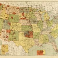
Map showing Indian reservations within the limits of the United States
Dublin Core
Title
Map showing Indian reservations within the limits of the United States
Subject
Reservations & Religion
Description
1892 map displaying the locations of reservations in the United States. The Kiowa reservation can be found in Southwest Oklahoma. Originally created for use by the Office of Indian Affairs.
Creator
Thomas Jefferson Morgan
Source
Library of Congress
Date
1892
Rights
The use of this image may be subject to the copyright law of the United States (Title 17, United States Code) or to site license or other rights management terms and conditions. The person using the image is liable for any infringement.
Identifier
Call Number: G3701.G6 1892 .U5
Still Image Item Type Metadata
Original Format
Map
Physical Dimensions
53x84cm
Files
Collection
Citation
Thomas Jefferson Morgan, “Map showing Indian reservations within the limits of the United States,” Nabb Research Center Online Exhibits, accessed January 10, 2026, https://libapps.salisbury.edu/nabb-online/items/show/582.

