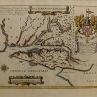
Nova Terra Maria Tabula Map
Dublin Core
Title
Nova Terra Maria Tabula Map
Subject
Delmarva History
Description
John Ogilby’s 1671 map of Maryland is oriented with north to the right, reflecting the purpose of chart design for ship captains approaching the entrance at the mouth of the Chesapeake Bay. Ogilby’s map is significant because it is the first to name the Maryland counties of Somerset, Dorchester, and Talbot as well as those on the Western Shore
Source
Nabb Research Center, Nabb Research Center Collection
Date
1671
Rights
The use of this image may be subject to the copyright law of the United States (Title 17, United States Code) or to site license or other rights management terms and conditions. The person using the image is liable for any infringement.
Identifier
2014.044.004
Files
Collection
Citation
“Nova Terra Maria Tabula Map,” Nabb Research Center Online Exhibits, accessed January 11, 2026, https://libapps.salisbury.edu/nabb-online/items/show/503.
